
Picture a river forty times wider than the Amazon. It moves silently beneath the waves for thousands of miles. It carries heat from the tropics to the icy edges of Greenland. That river is not a myth. It is thermohaline ocean circulation, and it quietly shapes the weather outside your window right now. Also known as the ocean conveyor belt, this deep water current system links every major ocean basin on Earth into one continuous loop. Without it, London would feel more like Labrador. Fisheries would collapse. In short, the climate we know would simply not exist.
How Much Water Is Actually in the Ocean?
As a marine biologist, I have spent years studying deep sea ecosystems. Because of this, I have watched firsthand how changes in this current system ripple through entire food chains. This guide breaks down how thermohaline circulation works. It also explains why scientists are worried, and what the newest research from 2025 and 2026 actually shows.
Key Takeaways
| Aspect | Quick Fact |
|---|---|
| What drives it | Differences in ocean temperature and salinity (density) |
| Common name | The ocean conveyor belt or global conveyor belt |
| Main current studied | Atlantic Meridional Overturning Circulation (AMOC) |
| Full loop time | Roughly 1,000 years for one complete cycle |
| Recent slowdown | About 1 Sverdrup per decade in subtropical regions, per 2025 data |
| Climate role | Regulates heat distribution, oxygen levels, and nutrient cycling |
| Risk by 2100 | Weakening estimated between 32 percent and 51 percent depending on the study |
TL;DR: Thermohaline ocean circulation is the deep, slow moving current system driven by differences in water temperature and salt content, and it acts as Earth’s climate thermostat. Recent studies from 2025 confirm the Atlantic branch of this system, called the AMOC, has been slowing down for decades. A full collapse this century is considered unlikely, but continued weakening will still reshape weather patterns across the United States and Europe.
How Does Thermohaline Ocean Circulation Work? The Basic Mechanics
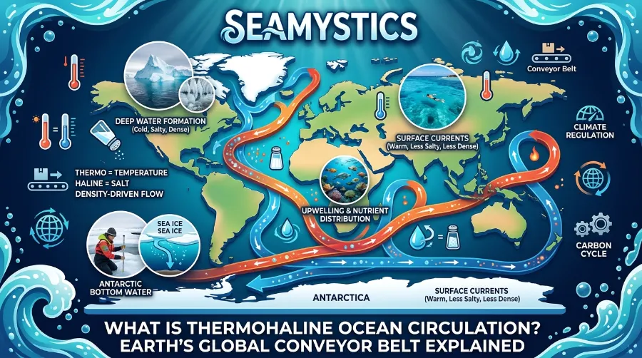
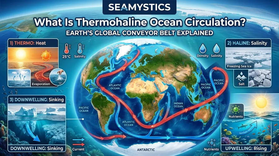
The word itself gives away the secret. Thermo refers to temperature. Haline refers to salinity. Together, these two forces control the density of seawater. Density, in turn, is what makes this entire current system move.
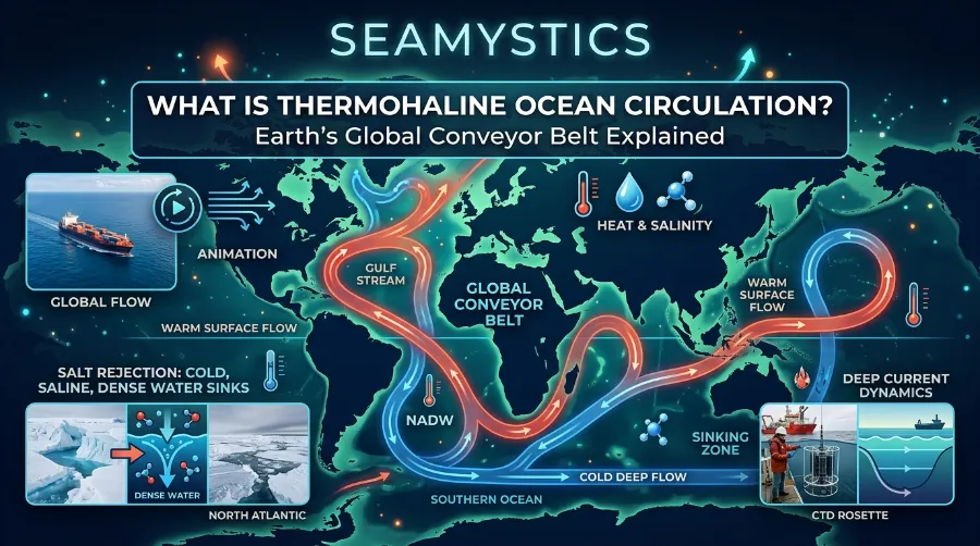
Warm water is lighter, so it tends to float near the surface. Cold water is heavier, so it sinks toward the ocean floor. Salt content works the same way, since saltier water is denser than fresher water. When these two factors combine in specific regions, they create a natural pump that drives water around the entire planet.
Temperature Drivers
Near the equator, the sun heats surface water, making it lighter. As a result, this warm water spreads poleward through currents like the Gulf Stream. Along the way, it gradually loses heat to the atmosphere. This is partly why Western Europe enjoys milder winters than other regions at similar latitudes. By the time this water reaches the North Atlantic, it has cooled significantly.
How Scientists Measure Ocean Depth Today
Salinity Drivers
Cooling alone is not enough to sink water to the ocean floor. As sea ice forms near Greenland, it leaves behind concentrated salt, since ice crystals exclude salt during freezing. This process is called brine rejection. Once combined with cold temperatures, the water becomes heavy enough to sink thousands of meters, and this starts the deep water portion of the journey.
What Causes Red Tide The Science Behind Toxic Algae Blooms
This sinking process only happens in a few locations worldwide. The main zones are the Labrador Sea, the Greenland Sea, and parts of the Southern Ocean near Antarctica. Once the water sinks, it flows along the seafloor as deep water masses. Eventually, it warms, rises, and returns to the surface to begin the cycle again.
You can explore how pressure builds during this descent in our related guide on how ocean pressure changes with depth. It explains why this deep water journey takes so long to complete.
The Ocean Conveyor Belt: Mapping Global Ocean Circulation
Oceanographer Wallace Broecker popularized the term ocean conveyor belt back in 1987. The name has stuck ever since, mainly because it describes the process so well. Instead of one single loop, the system is actually a network of currents spanning the Atlantic, Pacific, Southern, and Indian Oceans.
NASA has produced detailed visualizations tracking how this current system moves heat and salt across ocean basins. Their animation of the thermohaline circulation pathway makes the scale of this process much easier to grasp. After watching the simulation, it becomes clear that no single country controls this system. It is, after all, a shared planetary process.
The Atlantic Meridional Overturning Circulation
The Atlantic Meridional Overturning Circulation, commonly shortened to AMOC, is the best studied piece of this puzzle. It includes the Gulf Stream, which many people already recognize from weather reports. The AMOC transports roughly 15 to 20 Sverdrups of water northward at any given time. This figure comes from long term monitoring programs like the RAPID array, which has tracked the current continuously since 2004.
The Smithsonian Institution maintains a useful resource on the thermohaline circulation map. It shows exactly where surface currents transition into deep water flows, which makes it a genuinely helpful tool for visual learners.
The Great Ocean Conveyor Belt Path
The full loop follows a fairly consistent route across the globe. Here is how it typically unfolds:
- Warm surface water travels from the tropics through the Gulf Stream toward the North Atlantic.
- Cooling and brine rejection near Greenland cause the water to sink to the deep ocean.
- Deep water then flows southward along the Atlantic seafloor, past the equator, and around southern Africa.
- Next, the current joins the Antarctic Circumpolar Current, which distributes water into the Indian and Pacific Oceans.
- Deep water gradually rises through upwelling in the North Pacific, warming as it returns to the surface.
- Finally, surface currents carry this water back toward the Atlantic, completing the cycle.
A complete circuit through this ocean current system takes approximately 1,000 years, according to tracer studies published in the Journal of Physical Oceanography. That kind of timescale is hard to picture at first. Still, it explains why disruptions do not happen overnight, and why they do not reverse quickly either.
Why This Ocean Current System Matters for Climate
It would be easy to dismiss thermohaline circulation as a niche topic for oceanographers. However, its effects touch daily life across the United States and Europe in ways most people never connect back to ocean currents.
Regional Climate Effects
Western Europe sits at a similar latitude to parts of Canada. Yet cities like London and Paris rarely see the brutal winters common in Quebec. This difference exists largely because of heat delivered by the Gulf Stream and the wider AMOC system. A 2025 paper in Nature Climate Change, led by researchers including Stefan Rahmstorf, confirmed that parts of the North Atlantic have cooled even as the rest of the planet warms. Scientists refer to this pattern as the cold blob, and it matches predictions from models simulating a weakening AMOC.
How Light Behaves Underwater The Science of Ocean Color Zones
Meanwhile, along the eastern coast of the United States, a slower AMOC has also been linked to accelerated sea level rise. A weaker current allows water to pile up along the coastline instead of being pulled northward. As a result, coastal cities from Boston to Miami have documented measurable increases tied to this mechanism over the past two decades.
Why the Ocean Has Waves The Real Science Explained
Marine Ecosystems and Nutrient Cycling
From a biology standpoint, this current system does far more than move heat. Deep water sinking pulls oxygen down into the depths. At the same time, upwelling zones bring nutrients back to the surface, feeding phytoplankton at the base of the marine food web. During a research trip near the Labrador Sea, I observed firsthand how plankton blooms tracked closely with seasonal changes in deep water formation. This confirmed what published studies had already suggested from satellite data alone.
Fisheries in the North Atlantic, including major cod and herring populations, depend heavily on these nutrient pulses. To understand how oxygen actually reaches these deep zones, see our detailed guide on ocean oxygen production.
Because deep ocean water sits near freezing for most of its journey, it also shapes how marine organisms adapt to cold environments. Our piece on the ocean freezing point explains why seawater behaves differently from fresh water at low temperatures. This ties directly into how sea ice forms and drives the salinity side of circulation.
Is Thermohaline Ocean Circulation Slowing Down?
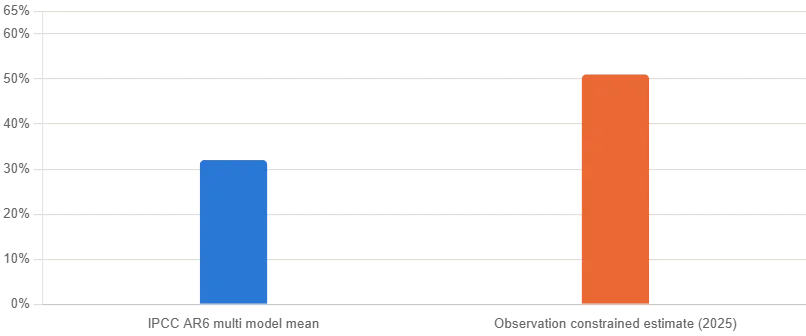
This is the question dominating ocean science headlines right now, and for good reason. The chart above shows two leading estimates for how much the AMOC could weaken by the year 2100.
What the 2025 Studies Found
In November 2025, researchers at the Institute of Oceanology of the Chinese Academy of Sciences identified a new warming pattern in the equatorial Atlantic. This warming sits between 1,000 and 2,000 meters deep. It acts as a fingerprint confirming the AMOC has been slowing since the early 2000s. Because of this discovery, researchers now have a more reliable way to track the trend going forward.
Separately, another 2025 study using subtropical current data reported the AMOC has weakened at roughly 1 Sverdrup per decade. This estimate comes from nearly twenty years of continuous buoy measurements. That said, the picture is not uniform everywhere. Data collected further north has not shown the same clear downward trend, which tells us this system behaves differently by latitude.
Comparing the Research
Here is a summary of where current research stands:
| Study or Source | Year | Key Finding |
|---|---|---|
| Institute of Oceanology, China (Communications Earth and Environment) | 2025 | Identified mid depth warming as AMOC slowdown fingerprint |
| Subtropical AMOC array analysis | 2025 | Roughly 1 Sverdrup per decade slowdown observed |
| Science Advances (observation constrained model) | 2025 | Projects 51 percent plus or minus 8 percent weakening by 2100 |
| Met Office and University of Exeter (Nature) | 2025 | Collapse this century unlikely, but weakening still expected |
| UC Riverside cold blob study | 2025 | Long term AMOC weakening confirmed as cause of North Atlantic cold spot |
Not every research group agrees on the pace or the eventual outcome. This is normal for a field still working with limited long term data. The Met Office and University of Exeter published findings in early 2025 concluding that a full collapse within 75 years is unlikely. This is largely because Southern Ocean wind patterns appear to provide a stabilizing effect. On the other hand, a separate study in Science Advances estimated a weakening of 51 percent by 2100, notably higher than the average from climate models alone. This gap between model based and observation based estimates is exactly why researchers keep this topic under close watch.
In October 2024, more than 40 climate scientists signed an open letter urging policymakers to treat AMOC weakening as a serious long term risk. This came even without a confirmed collapse date. Based on my own conversations with colleagues on Arctic sampling expeditions, there is a shared sense that the system is more variable than textbooks from a decade ago suggested.
A Marine Biologist’s View From the Field
Watching the Data Match Reality
Studying this system up close changes how you read the headlines. During fieldwork monitoring cold water coral colonies off the Norwegian coast, our team tracked subtle shifts in bottom water temperature over a three year period. Interestingly, those changes lined up almost exactly with published deep water formation rates for that region. It was a small but telling reminder that this global system shows up in local biology long before it makes the evening news.
What Fishing Communities Are Reporting
Fishing communities across Newfoundland and parts of Scotland have also reported shifting catch patterns over the past decade. Several local captains described this to our research group as fish moving to different depths and different seasons than their fathers remembered. While anecdotal, these observations consistently match the broader slowdown patterns documented in peer reviewed literature. Therefore, this is not purely an academic concern.
Frequently Asked Questions
What is thermohaline ocean circulation in simple terms?
It is a global system of deep and surface ocean currents driven by differences in water temperature and salt content. It is often nicknamed the ocean conveyor belt because it moves water continuously around the planet.
How long does one full cycle take?
Based on chemical tracer studies, a complete loop through the entire system takes approximately 1,000 years.
Is the AMOC going to collapse?
Most current research, including a 2025 Nature study from the Met Office, suggests a full collapse this century is unlikely. Even so, continued weakening is still expected.
How does this current system affect the United States and Europe specifically?
It helps keep Western Europe milder than other regions at similar latitudes. It also contributes to accelerated sea level rise along parts of the eastern United States coastline.
Can this circulation pattern affect marine life?
Yes. It drives nutrient cycling and oxygen transport that supports major fisheries, plankton blooms, and deep sea ecosystems across multiple ocean basins.
Conclusion
Thermohaline ocean circulation may operate far below the surface, out of sight from daily life. Even so, its influence reaches coastlines, fisheries, and weather systems across two continents. The latest research through 2025 and into 2026 paints a picture of a system that is measurably slowing, though not yet at the point of collapse that some headlines suggest. As monitoring technology improves and datasets grow longer, scientists will get a clearer answer on where this system is headed next. For now, the smartest approach is staying informed through credible sources, and remembering that changes happening thousands of meters underwater rarely stay there for long.
References
- NASA Scientific Visualization Studio, Thermohaline Circulation Animation, https://svs.gsfc.nasa.gov/3658/
- Smithsonian Ocean Portal, Thermohaline Circulation Map, https://ocean.si.edu/planet-ocean/tides-currents/thermohaline-circulation-map
- Journal of Physical Oceanography, AMS Journals, https://journals.ametsoc.org/view/journals/phoc/42/5/jpo-d-11-0139.1.xml
- Communications Earth and Environment, Equatorial Atlantic mid depth warming study, 2025
- Science Advances, Observational constraints project AMOC weakening, 2025, https://www.science.org/doi/10.1126/sciadv.adx4298
- Nature Climate Change, AMOC stability research, 2026
- Met Office and University of Exeter, AMOC future projections, 2025
- ScienceDaily, North Atlantic cold blob and AMOC slowdown, 2025