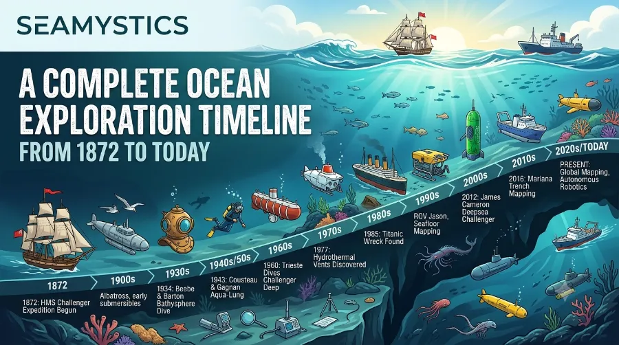

The ocean exploration timeline facts reveal one of the greatest scientific journeys in human history. From the groundbreaking HMS Challenger expedition in 1872 to today’s AI-powered deep-sea robots, every milestone has expanded our understanding of Earth’s largest ecosystem. Although the ocean covers more than 70% of our planet, scientists have explored only a small fraction of its depths. This complete timeline highlights the discoveries, technologies, and expeditions that transformed marine science and continue to shape research, conservation, and climate studies today.
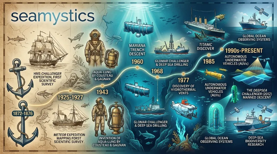
The ocean covers more than 70% of Earth’s surface, yet scientists estimate that a large part of the deep sea remains unexplored. Every major expedition has expanded our understanding of marine life, geology, climate, and Earth’s history. From the famous HMS Challenger voyage in 1872 to today’s robotic expeditions, ocean exploration has evolved through remarkable scientific breakthroughs.
Key Takeaways
| Topic | Key Insight |
|---|---|
| Starting Point | Modern scientific ocean exploration began in 1872 with HMS Challenger. |
| Biggest Innovation | Sonar, ROVs, AUVs, and satellite mapping transformed exploration. |
| Deepest Human Dive | Mariana Trench reached by Bathyscaphe Trieste in 1960. |
| Modern Era | AI, autonomous robots, and high-resolution seabed mapping now lead discoveries. |
| Why It Matters | Ocean exploration improves climate research, biodiversity protection, fisheries, and disaster forecasting. |
Why the Ocean Exploration Timeline Matters
Ocean exploration is much more than searching the seafloor. Scientists study underwater volcanoes, deep-sea animals, ocean currents, and climate systems that influence life across the planet.
Today, research vessels can collect thousands of gigabytes of information during a single expedition. Modern remotely operated vehicles can dive where humans cannot safely travel. Meanwhile, advanced sonar systems map vast areas of the seabed with impressive accuracy.
You may also enjoy:
- /marine-protected-areas-guide
- /deep-sea-creatures
- /Mariana-trench-facts
Ocean Exploration Timeline Facts: 1872–1900
1872–1876: The HMS Challenger Expedition
Everything changed in December 1872.
The British research vessel HMS Challenger departed England on what became the world’s first dedicated scientific ocean expedition. Instead of searching for trade routes or colonies, the crew focused entirely on science.
During nearly four years at sea, researchers:
- Surveyed about 127,000
- Collected thousands of marine specimens
- Recorded hundreds of ocean depth measurements
- Sampled seawater worldwide
- Discovered more than 4,000 previously unknown species
These discoveries laid the foundation for modern oceanography. Scientists also proved that life exists even in the deepest parts of the ocean, overturning earlier beliefs.
Major Achievements
| Achievement | Importance |
|---|---|
| Global ocean survey | First comprehensive scientific expedition |
| Deep-sea dredging | Revealed unknown marine animals |
| Water chemistry analysis | Improved understanding of ocean circulation |
| Temperature profiling | Opened modern physical oceanography |
1880s: Purpose-Built Research Ships
Following Challenger’s success, countries invested heavily in marine science.
Research vessels such as Albatross introduced stronger steel cables, improved dredging equipment, and specialized laboratories. Scientists began studying fisheries, ocean currents, and deep-sea ecosystems on a much larger scale.
The Early 1900s: A New Era Begins
The twentieth century brought rapid technological progress.
Instead of relying only on weighted ropes, researchers developed better sounding equipment and more accurate navigation tools.
Several important advances included:
- Improved steel wire sounding
- Better ocean charts
- Reliable sampling devices
- More accurate current measurements
As a result, scientists produced increasingly detailed maps of the ocean floor.
1930–1960: The Birth of Deep-Sea Exploration
The early twentieth century transformed ocean exploration from surface observations into direct exploration of the deep sea. New diving technology allowed scientists to see deep-water environments with their own eyes instead of relying only on collected samples.
As engineering improved, researchers reached depths that had once seemed impossible. These achievements changed marine biology forever.
1930: Humans First Observe the Deep Ocean
In the summer of 1930, American naturalist William Beebe and engineer Otis Barton descended hundreds of meters beneath the Atlantic Ocean inside the Bathysphere, a steel sphere suspended by a cable.
Unlike previous expeditions, this mission allowed scientists to observe living deep-sea animals in their natural habitat.
The expedition revealed:
- Bioluminescent fish
- Deep-sea jellyfish
- Unusual crustaceans
- Species never observed alive before
These observations inspired decades of marine biology research and demonstrated that direct exploration could answer questions that dredging never could.
Why the Bathysphere Was Revolutionary
| Innovation | Scientific Benefit |
|---|---|
| Steel observation sphere | Safe human descent into deep water |
| Viewing ports | Direct observation of marine life |
| Voice communication | Real-time scientific reporting |
| Repeat dives | Consistent biological observations |
1934: A New Depth Record
Only four years later, Beebe and Barton descended to approximately 923 meters (3,028 feet), setting a new human depth record.
At this depth, sunlight disappears completely. The team observed glowing organisms, unusual fish, and strange behaviors that challenged existing theories about life under extreme pressure.
Scientists also confirmed that many deep-sea animals produce their own light through bioluminescence, an adaptation that remains one of the ocean’s most fascinating survival strategies.
The 1940s: Sonar Changes Everything
The outbreak of the Second World War accelerated technological development. Navies invested heavily in underwater detection systems, leading to rapid improvements in SONAR (Sound Navigation and Ranging).
Although sonar was designed for military use, scientists quickly recognized its value for ocean research after the war.
Instead of lowering weighted ropes into the sea, researchers could now send sound waves toward the seafloor and measure the time required for the echo to return.
This innovation dramatically improved the speed and accuracy of seabed mapping. It also revealed underwater mountains, trenches, and volcanic ridges that had remained hidden for centuries.
Benefits of Sonar Mapping
- Faster ocean-floor surveys
- More accurate depth measurements
- Discovery of underwater mountain ranges
- Better navigation for research vessels
- Improved understanding of plate tectonics
The Discovery of the Mid-Ocean Ridge System
As sonar surveys expanded during the 1950s, scientists discovered a continuous chain of underwater mountains stretching across the world’s oceans.
This immense feature, known as the Mid-Ocean Ridge, extends for more than 65,000 kilometers (40,000 miles), making it the longest mountain range on Earth.
The discovery helped researchers understand how tectonic plates move and how new ocean crust forms.
Later, this evidence became one of the strongest foundations for the theory of plate tectonics, which transformed Earth science.
1953: Mapping the Deepest Ocean
During the early 1950s, improved echo-sounding technology produced increasingly accurate maps of the Mariana Trench.
Scientists confirmed that the trench reached extraordinary depths exceeding 10,900 meters, making it the deepest known place on Earth.
These surveys also demonstrated that many ocean trenches formed where one tectonic plate slides beneath another.
The findings connected marine geology with earthquakes and volcanic activity, helping researchers better understand natural hazards.
1960: The Historic Dive to Challenger Deep


One of the greatest milestones in ocean exploration occurred on January 23, 1960.
Swiss oceanographer Jacques Piccard and U.S. Navy Lieutenant Don Walsh descended aboard the Bathyscaphe Trieste to Challenger Deep, the deepest known point in the ocean.
After nearly five hours of descent, they reached a depth of about 10,916 meters (35,814 feet), although later measurements using improved technology refined the exact depth.
At the bottom, they observed:
- Flat sediment plains
- Deep-sea organisms
- Small shrimp-like crustaceans
- Signs that life survives under extreme pressure
Although visibility remained limited, the expedition proved that humans could safely reach the deepest part of the ocean.
Trieste Mission Highlights
| Fact | Detail |
|---|---|
| Dive Date | January 23, 1960 |
| Destination | Challenger Deep |
| Ocean | Western Pacific |
| Maximum Depth | Approximately 10,916 m |
| Crew | Jacques Piccard and Don Walsh |
| Mission Length | Nearly 9 hours round trip |
Scientific Impact of the Trieste Expedition
The Trieste dive became far more than a record-setting achievement.
It demonstrated that specially designed submersibles could operate in one of the harshest environments on Earth, where pressure exceeds 1,000 times the atmospheric pressure at sea level.
The expedition encouraged governments and research institutions to invest in stronger deep-sea vehicles, better underwater cameras, and advanced scientific instruments.
Many technologies used in today’s crewed submersibles and remotely operated vehicles trace their origins to lessons learned from the Trieste program.
Ocean Exploration Progress (1872–1960)
| Period | Major Breakthrough | Long-Term Impact |
|---|---|---|
| 1872–1876 | HMS Challenger Expedition | Birth of modern oceanography |
| 1930 | First Bathysphere dive | Direct observation of deep-sea life |
| 1934 | Human depth record | Expanded biological research |
| 1940s | Sonar development | Accurate seabed mapping |
| 1950s | Mid-Ocean Ridge discovery | Supported plate tectonics |
| 1960 | Trieste reaches Challenger Deep | Opened the era of human deep-sea exploration |
1964–2000: Robots, Hydrothermal Vents, and a New View of the Deep Ocean
The decades after the historic Trieste dive marked a turning point in marine science. Instead of relying mainly on crewed submersibles, researchers developed remotely operated vehicles (ROVs), satellites, and advanced sonar systems that could explore larger areas for longer periods.
As a result, scientists uncovered ecosystems that no one had imagined before. These discoveries reshaped biology, geology, and climate research.
1964–1970: The Rise of Deep-Sea Submersibles
Several countries invested in crewed research submersibles capable of repeated scientific missions.
Unlike the one-time record-setting dives of the early years, these vehicles allowed scientists to collect rock samples, study marine animals, and photograph the seafloor in remarkable detail.
Important improvements included:
- Stronger titanium pressure hulls
- Better underwater cameras
- Mechanical robotic arms
- Longer underwater missions
- Improved navigation systems
These advances made routine deep-sea science possible rather than exceptional.
1977: The Discovery of Hydrothermal Vents


One of the greatest discoveries in marine biology occurred in 1977 near the Galápagos Rift.
Scientists exploring the Pacific Ocean expected to find a barren seafloor. Instead, they discovered towering hydrothermal vents, often called black smokers, surrounded by thriving ecosystems.
Researchers observed:
- Giant tube worms
- White crabs
- Deep-sea clams
- Shrimp
- Unique bacteria
The biggest surprise was that these organisms survived without sunlight.
Instead of relying on photosynthesis, microorganisms used chemicals released from Earth’s crust through a process known as chemosynthesis.
This finding changed one of biology’s most fundamental assumptions—that nearly all life depends directly or indirectly on sunlight.
Why Hydrothermal Vents Matter
| Discovery | Scientific Importance |
|---|---|
| Chemosynthesis | Demonstrated an alternative energy source for life |
| Tube worm colonies | Revealed highly specialized deep-sea ecosystems |
| Mineral-rich vents | Improved understanding of seafloor geology |
| Heat-loving microbes | Expanded research into life’s limits on Earth |
Scientists also began considering whether similar ecosystems could exist beneath the icy oceans of moons such as Europa and Enceladus.
1985: Finding the Titanic


In 1985, an international expedition led by oceanographer Robert Ballard located the wreck of the RMS Titanic in the North Atlantic Ocean.
The discovery relied on advanced underwater cameras, sonar mapping, and remotely operated technology.
The mission proved that robotic exploration could locate historically significant sites thousands of meters below the surface.
Beyond its historical importance, the expedition advanced:
- Deep-sea imaging
- Underwater robotics
- Archaeological survey methods
- Ocean mapping techniques
Many technologies refined during the Titanic mission later supported scientific expeditions around the world.
The 1990s: Satellites Transform Ocean Science
While submersibles explored the ocean floor, satellites began monitoring the ocean from space.
Satellite observations allowed researchers to measure:
- Sea surface temperature
- Ocean color
- Chlorophyll concentrations
- Ocean circulation
- Sea level changes
These datasets improved weather forecasting and climate modeling while helping scientists monitor marine ecosystems across the globe.
For the first time, researchers could combine observations from space with measurements collected deep beneath the ocean.The Growth of Remotely Operated Vehicles (ROVs)
During the 1980s and 1990s, ROVs became essential tools for ocean exploration.
Unlike crewed submersibles, ROVs remain connected to research ships through long cables that provide power and transmit live video.
Modern ROVs can:
- Dive deeper than most human-occupied vehicles
- Collect biological samples
- Recover geological specimens
- Inspect underwater volcano
- Study shipwrecks
- Operate for many hours
Because they remove the risks associated with human dives, ROVs greatly expanded scientific exploration.
Human-Occupied Submersibles vs. ROVs
| Feature | Human Submersible | ROV |
|---|---|---|
| Crew onboard | Yes | No |
| Dive duration | Limited | Longer |
| Risk to humans | Higher | Very low |
| Live video | Limited in early models | High-definition |
| Sample collection | Yes | Yes |
| Typical missions | Scientific observation | Research, industry, archaeology |
Better Maps Reveal a Hidden World
Improved multibeam sonar systems dramatically increased mapping accuracy during the 1990s.
Scientists identified:
- Underwater volcanoes
- Deep canyons
- Seamounts
- Cold seeps
- Coral reefs
- Massive submarine landslides
Researchers also realized that large portions of the seafloor remained unmapped despite decades of exploration.
This realization inspired global initiatives to improve seabed mapping in the twenty-first century.
Ocean Exploration Timeline (1964–2000)
| Year | Milestone | Importance |
|---|---|---|
| 1964 | Improved research submersibles | Expanded routine deep-sea science |
| 1977 | Hydrothermal vents discovered | Revolutionized marine biology |
| 1985 | Titanic located | Advanced robotic exploration |
| Late 1980s | ROV technology matured | Increased exploration safety and efficiency |
| 1990s | Satellite oceanography expanded | Enhanced climate and ocean monitoring |
| 1990s | Multibeam sonar improved | Produced more detailed seabed maps |
How Technology Changed Ocean Exploration
| Technology | Before | After |
|---|---|---|
| Sonar | Basic depth readings | Detailed 3D seafloor maps |
| Submersibles | Short observation dives | Long scientific missions |
| ROVs | Rare experimental tools | Standard research equipment |
| Satellites | Limited ocean data | Continuous global monitoring |
| Cameras | Low resolution | High-definition underwater imaging |
2001–Today: The Digital Age of Ocean Exploration
The twenty-first century has transformed ocean exploration into a global effort powered by robotics, artificial intelligence (AI), high-resolution mapping, and international collaboration. Scientists can now explore remote seafloor regions with greater speed and precision than ever before.
Although these advances are remarkable, the ocean still holds countless mysteries. According to NOAA Ocean Exploration, humans have directly observed less than 0.001% of the deep seafloor, and only 28.7% of the global seabed had been mapped to modern standards by April 2026.
2000s: Autonomous Underwater Vehicles (AUVs)
Unlike remotely operated vehicles (ROVs), autonomous underwater vehicles (AUVs) do not require cables connecting them to a research ship. Instead, they follow pre-programmed routes while collecting valuable scientific data.
Today, AUVs help researchers:
- Create detailed seafloor maps
- Measure water temperature and salinity
- Detect underwater volcanoes
- Monitor coral reef health
- Search for shipwrecks
- Explore beneath sea ice
Because AUVs can work for many hours without human intervention, they have become essential tools for deep-ocean exploration.
ROV vs. AUV
| Feature | ROV | AUV |
|---|---|---|
| Connected to ship | Yes | No |
| Human control | Continuous | Autonomous |
| Best for | Sampling and repairs | Mapping and surveys |
| Endurance | Moderate | Long-duration missions |
2010–2020: Mapping the Unknown Ocean
As computing power improved, scientists began combining multibeam sonar, satellite observations, and AI-assisted data processing to produce highly detailed maps of the ocean floor.
One of the most ambitious projects is Seabed 2030, an international initiative aiming to map the entire ocean floor by the year 2030.
The project brings together governments, universities, research institutes, and private organizations to create a freely available global bathymetric map.
Progress Toward Mapping the Ocean Floor
| Year | High-Resolution Seafloor Mapped |
|---|---|
| 2017 | ~6% |
| 2020 | ~20% |
| 2023 | ~25% |
| April 2026 | 28.7% |
2023–2026: Ocean Census and AI-Powered Discovery
Another major milestone arrived with the launch of the Ocean Census, a global scientific initiative dedicated to accelerating the discovery of marine species.
Using high-resolution imaging, environmental DNA (eDNA), robotics, and machine learning, researchers are identifying marine organisms much faster than ever before.
In 2026, the project announced the discovery of more than 1,100 new marine species, highlighting how much biodiversity remains undocumented.
Scientists believe that only a small fraction of ocean species has been formally described. Continued exploration is expected to reveal thousands of additional organisms over the coming decades.
2026: Ocean Exploration Continues
Today, research organizations continue exploring the Pacific Ocean, Caribbean Sea, polar regions, and other understudied environments.
Modern expeditions combine:
- Artificial intelligence
- High-definition cameras
- Environmental DNA sampling
- Real-time satellite communication
- Autonomous robots
- Advanced sonar systems
These technologies allow scientists to map seafloor habitats, study marine ecosystems, monitor climate change, and discover previously unknown geological features.
Complete Ocean Exploration Timeline (1872–2026)
| Year | Event | Why It Matters |
|---|---|---|
| 1872 | HMS Challenger Expedition begins | Birth of scientific oceanography |
| 1930 | First Bathysphere dive | Humans observe deep-sea life |
| 1934 | New human depth record | Expanded deep-ocean research |
| 1940s | Sonar advances | Faster and more accurate mapping |
| 1950s | Mid-Ocean Ridge mapped | Supported plate tectonics |
| 1960 | Trieste reaches Challenger Deep | Deepest crewed ocean dive |
| 1977 | Hydrothermal vents discovered | Changed understanding of life’s origins |
| 1985 | Titanic wreck located | Advanced deep-sea robotics |
| 1990s | Satellite oceanography expands | Improved climate and ocean monitoring |
| 2000s | AUVs become common | Autonomous exploration grows |
| 2017 | Seabed 2030 launched | Global mapping initiative |
| 2023 | Ocean Census begins | Accelerated species discovery |
| 2026 | AI-assisted exploration expands | Faster mapping and biodiversity research |
Ocean Exploration Technology Evolution
| Era | Primary Technology | Impact |
|---|---|---|
| 1870s | Rope sounding | Basic depth measurements |
| 1930s | Bathysphere | Human observation |
| 1940s | Sonar | Accurate mapping |
| 1960s | Submersibles | Deep-sea research |
| 1980s | ROVs | Remote exploration |
| 2000s | AUVs | Autonomous surveys |
| 2020s | AI + eDNA + Robotics | Rapid discovery and analysis |
Ocean Exploration Progress (Visual Chart)Scientific Exploration Progress
1872  █
1900  ██
1930  ███
1960  ██████
1985  ████████
2000  █████████
2026 ██████████Ocean exploration benefits people around the world by supporting:
- Climate change research
- Fisheries management
- Marine conservation
- Earthquake and tsunami monitoring
- Offshore renewable energy planning
- Medical discoveries from marine organisms
- Sustainable use of ocean resources
Furthermore, every new expedition improves our understanding of Earth’s largest ecosystem and helps protect it for future generations.
Frequently Asked Questions
When did modern ocean exploration begin?
Modern scientific ocean exploration began in 1872 with the HMS Challenger expedition, the first voyage dedicated entirely to ocean science.
What is the deepest place humans have reached?
Humans first reached Challenger Deep in the Mariana Trench on January 23, 1960, aboard the Bathyscaphe Trieste.
How much of the ocean has been explored?
Scientists estimate that humans have directly observed less than 0.001% of the deep seafloor. About 28.7% of the world’s seabed had been mapped to modern standards by April 2026.
What technologies are used today?
Modern exploration relies on multibeam sonar, remotely operated vehicles (ROVs), autonomous underwater vehicles (AUVs), artificial intelligence, environmental DNA analysis, satellite observations, and high-definition imaging.
Why is ocean exploration important?
It improves climate science, biodiversity conservation, disaster preparedness, sustainable fisheries, and our understanding of Earth’s geology and ecosystems.
Conclusion
The ocean exploration timeline facts show an extraordinary journey from simple rope soundings in 1872 to today’s AI-powered underwater robots. Every generation has introduced new technologies that expanded humanity’s understanding of the deep ocean, revealing hidden mountain ranges, hydrothermal vents, shipwrecks, and countless new species.
Even after more than 150 years of exploration, the ocean remains Earth’s greatest frontier. With international projects such as Seabed 2030 and the Ocean Census, scientists are steadily uncovering the secrets of the deep. Each new expedition not only answers old questions but also raises exciting new ones, ensuring that ocean exploration will remain one of the most important scientific endeavors of the twenty-first century.
References
- NOAA Ocean Exploration
- NOAA – How Much of the Ocean Has Been Explored?
- Seabed 2030
- International Hydrographic Organization – Seabed 2030 Update
- Ocean Census
About the Author
Dr. Rabica is a marine biologist and science communicator with more than 20 years of experience studying deep-sea ecosystems, marine biodiversity, and ocean exploration. Through Sea Mystics, Dr. Rabica translates complex marine science into engaging, evidence-based articles that help readers better understand and appreciate the world’s oceans.