
Picture a research ship gliding over open water at three in the morning. The crew sleeps. The hull quietly fires thousands of sound pulses into the dark below. Nobody on board can see what’s happening beneath them. By sunrise, a mountain range nobody knew existed appears on a screen. That is deep sea sonar at work. It is one of the quietest revolutions in modern ocean science.
Most people assume we’ve already mapped the seafloor the way we mapped the moon. We haven’t. As of April 2026, researchers have mapped only about 28.7% of the global seafloor at high resolution, according to NOAA Ocean Exploration. More than two thirds of the planet’s seabed remains, functionally, a blank space. Sonar is closing that gap. Understanding how it actually works explains why ocean maps keep changing. It also explains why new seamounts keep turning up in the news.
Key Takeaways
| Aspect | What You Need to Know |
|---|---|
| Core method | Sound pulses bounce off the seafloor. Travel time gives us depth |
| Main tool today | Multibeam sonar mapping reads hundreds of points per single ping |
| Current coverage | 28.7% of the seafloor is mapped at high resolution as of April 2026 |
| Global goal | Seabed 2030 aims for complete high-resolution coverage by the end of the decade |
| Resolution range | Roughly 100 meters from a ship hull down to about 1 meter with towed or robotic sensors |
| Depth capability | Modern systems operate from 10 meters down to over 7,000 meters |
| Why it matters | Navigation safety, cable routing, climate research, and species discovery all depend on it |
TL;DR: Deep sea sonar sends sound pulses toward the ocean floor and times the echo. That timing converts directly into depth. Modern multibeam sonar mapping fires hundreds of these pulses in a fan shape with every ping. One ship can survey a wide strip of seafloor instead of a single point. Most of the ocean floor still remains unmapped in detail. That gap is exactly why sonar-equipped expeditions keep finding mountains, canyons, and creatures nobody had recorded before.
What Deep Sea Sonar Actually Is
Sonar stands for sound navigation and ranging. It relies on a simple fact. Sound travels through water far better than light or radio waves. Light gets absorbed within roughly 200 meters. Sound keeps going for kilometers. So sonar doesn’t try to see the seafloor. It listens for it instead.
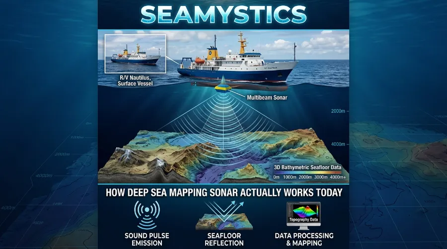
A transducer works like an underwater speaker and microphone in one unit. It sends a pulse of sound downward. The pulse hits the seafloor and bounces back as an echo. Seawater carries sound at a fairly consistent speed, around 1,500 meters per second. We calculate depth from the round-trip travel time. It sounds almost too simple for something that maps mountain ranges taller than the Rockies. Yet that is the entire foundation.
The Future of Ocean Exploration: What’s Next After 2026
There are two broad categories worth knowing if you’re trying to understand how sonar works ocean exploration today:
- Active sonar sends its own sound pulse and listens for the return. Nearly all seafloor mapping relies on this method.
- Passive sonar only listens. It picks up sounds already present in the water. Researchers use it more for detecting marine life or vessels than for mapping terrain.
From Single Beam to Multibeam Sonar Mapping
Older sonar systems send a single narrow beam straight down. Small boats and simple depth finders still use this method. It gives you one depth reading directly beneath the hull. It works, but it moves painfully slowly for anything the size of an ocean.
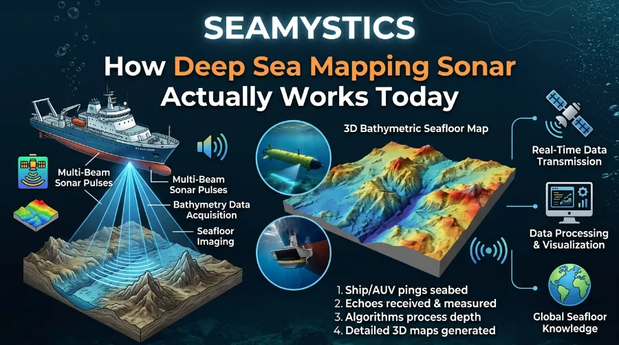
Modern multibeam sonar mapping changed that math completely. A multibeam system fires a fan of sound instead of one beam. That fan can span more than 150 degrees. During a NOAA-led survey of the New England Seamount Chain, the ship’s hull-mounted transducer transmitted up to 288 individual beams. It collected as many as 864 depth measurements from a single ping. One ping, hundreds of data points, an entire swath of seafloor mapped in the time it takes to blink.
That swath width scales with depth. In shallow coastal water, a survey strip might only span a few hundred meters. In the deep ocean, the same system can paint a corridor several kilometers wide with each pass. The sound simply has more room to fan out before it hits bottom.
A few numbers put the scale of this work in perspective:
- During the Beyond the Blue Hawaiʻi Mapping expedition, from May 14 to June 9, 2024, NOAA Ship Okeanos Explorer collected roughly 41,435 square kilometers of seafloor bathymetry in waters deeper than 200 meters.
- During the Seascape Alaska 1 expedition in May 2023, the same kind of survey work covered nearly 54,000 square kilometers of unmapped seafloor off Alaska in just three weeks.
- A single survey vessel would need roughly 350 years to properly map the seabed below 200 meters on its own. That’s exactly why fleets of ships, robots, and international partners now work the problem together.
Resolution: The Part Nobody Explains Well
Resolution is where most explanations of sonar technology explained for a general audience fall apart. It’s worth slowing down here.
A hull-mounted multibeam system on a ship typically resolves features between 30 and 100 meters wide. That number gets coarser as depth increases, because the sound beam spreads wider the farther it travels. This works fine for regional mapping and general navigation charts. It doesn’t work for finding aircraft wreckage or a single shipwreck on the bottom.
For that level of detail, engineers move the sonar closer to the target. Towed instruments and autonomous underwater vehicles carry multibeam sensors within a few hundred meters of the seafloor instead of a few thousand. Resolution jumps to around 1 meter. Investigators used exactly this approach during the search for Malaysian Airlines Flight MH370. They combined lower-resolution satellite-derived bathymetry with much sharper, close-range multibeam swaths to search the same stretch of seafloor southwest of Australia in far greater detail.
So why do some ocean maps look blurry while others look razor sharp? The honest answer comes down to how close the sensor sat to the bottom, not how “advanced” the sonar was in some abstract sense.
How Deep Can Modern Sonar Actually Reach
Depth capability has grown considerably. Multibeam systems on vessels like Okeanos Explorer operate reliably from about 10 meters down to roughly 7,000 meters. When the ship crossed the Mariana Trench, the deepest point in any ocean, its sonar still detected the seafloor at 8,000 meters. Only the very deepest sliver of the trench sits beyond routine reach. That’s a remarkable technical achievement, since the trench itself bottoms out near 11,000 meters.
Below that extreme depth, specialized systems built into deep-diving submersibles take over. They often work alongside sonar rather than replace it. Visual cameras remain nearly useless once natural light disappears past a few hundred meters.
Why Modern Sonar Mapping Still Leaves Most of the Ocean Blank
This part surprises most readers. Even with all this technology, modern sonar mapping has covered only 28.7% of the global seafloor at high resolution. That’s up from roughly 23% just a few years earlier. The Nippon Foundation-GEBCO Seabed 2030 Project exists specifically to close that gap. It coordinates research institutes, navies, and private companies around one shared goal: a complete high-resolution map of the entire ocean floor.
Why has this taken so long? A few practical reasons stand out:
- Ocean coverage is enormous, roughly 71% of the planet’s surface, and ships can only cover so much ground per day
- Deep water surveys need calm conditions, calibrated equipment, and continuous 24-hour operations to run efficiently
- Much of the historical “mapping” people mention is actually low-resolution satellite-derived bathymetry, not direct sonar measurement, and the two aren’t equivalent
- Funding and vessel time stay limited, so most expeditions prioritize areas with clear scientific, economic, or safety value first
That gap also explains why sonar-equipped expeditions keep making headlines. During a 2023 Okeanos Explorer expedition roughly 645 kilometers off Vancouver Island, researchers using multibeam sonar found a seamount rising 3,105 meters from the seafloor. That’s a full third taller than earlier estimates based on satellite data alone. Similar surprises have turned up repeatedly across the Pacific and Atlantic. Nobody had simply pointed a proper sonar array at those coordinates before.
What Sonar Data Is Actually Used For
It’s tempting to think of seafloor mapping as pure science for its own sake. The practical applications go well beyond curiosity:
- Maritime navigation safety. Updated nautical charts help vessels avoid uncharted seamounts and shoals.
- Submarine cable and pipeline routing. Companies need accurate terrain data before laying infrastructure across the seabed, a topic closely tied to how deep sea cables get planned in the first place.
- Climate and ocean circulation research. Seafloor shape influences current patterns and heat distribution.
- Habitat mapping and conservation. Sonar identifies coral reefs, seamounts, and vent systems worth protecting.
- Search operations. High-resolution swaths cover search zones methodically instead of by guesswork, whether teams are hunting for downed aircraft or lost vessels.
This data increasingly feeds directly into autonomous exploration too. Robotic platforms working alongside programs like the Ocean Exploration Trust and NOAA’s own ocean exploration missions use sonar for more than recording the seafloor. They navigate it in real time, adjusting course as terrain data streams in.
Where the Technology Is Heading Next
A few developments deserve attention over the next few years:
- Crowdsourced bathymetry. Commercial ships and even private vessels now contribute depth data from their own onboard sonar. This fills gaps faster than dedicated research fleets ever could alone.
- AI-assisted data processing. These tools now flag anomalies, like unexpected terrain features or biological targets, automatically instead of requiring a technician to review every swath by hand.
- Swarms of autonomous underwater vehicles. Multiple robots now map in parallel, replacing the old model of one ship covering one line at a time. This shift ties closely to the broader growth of autonomous underwater vehicles across ocean science.
- Integration with satellite altimetry. Teams use low-resolution satellite estimates to prioritize which unmapped regions likely hide significant features. This approach complements, rather than replaces, satellite ocean mapping.
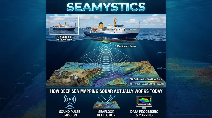
None of this changes the basic physics involved. Sound still has to travel down, bounce, and travel back. What’s changing is how fast that data gets collected, processed, and turned into something scientists, governments, and the public can actually use.
A Quick Look at the Coverage Numbers
| Year | Global Seafloor Mapped at High Resolution | Primary Driver |
|---|---|---|
| ~2017 | Roughly 6% | Early Seabed 2030 baseline |
| ~2020 | Roughly 20% | Expanded institutional and government mapping efforts |
| ~2023 | Roughly 23% | Crowdsourced data and new AUV deployments |
| April 2026 | 28.7% | Continued multibeam expeditions and international coordination |
| 2030 target | 100% | Seabed 2030 Project completion goal |
Readers who want to dig deeper into the underlying acoustic science can start with NOAA’s dedicated sonar research pages and the GEBCO Seabed 2030 project overview. Industry blogs like Sonardyne’s technical blog and Ocean Sonics cover equipment-level detail for anyone working directly with survey hardware. NOAA’s Teacher at Sea sonar coverage offers a more approachable, field-journal style view of what these expeditions look like day to day.
Frequently Asked Questions
What is the difference between multibeam and side-scan sonar?
Multibeam sonar measures depth directly beneath and to either side of the ship. It produces an accurate 3D bathymetric map. Side-scan sonar instead produces a photograph-like image of the seafloor surface. It works better for spotting objects like wrecks but delivers less precise depth measurement.
How accurate is modern deep sea sonar?
Accuracy depends heavily on depth and platform. Ship-mounted systems typically resolve features between 30 and 100 meters wide. Sensors mounted on autonomous underwater vehicles operating close to the seafloor resolve features down to about 1 meter.
Why hasn’t the entire ocean floor been mapped yet, if the technology already exists?
Coverage, not capability, creates the bottleneck. The ocean is simply too large for the current fleet of survey vessels to cover quickly. That’s why international projects like Seabed 2030 now pool resources from governments, universities, and private companies.
Can commercial ships help map the ocean floor?
Yes. Many cargo and cruise vessels already carry basic sonar for navigation. New programs collect that depth data voluntarily to help fill gaps in low-priority areas that dedicated research ships rarely visit.
Does sonar harm marine life?
Some high-intensity military and seismic sonar systems have raised documented concerns for marine mammals, particularly whales. Standard scientific multibeam mapping sonar operates at lower frequencies and intensities that most researchers consider lower risk. Researchers still continue to study and refine best practices around this.
Test What You Just Learned
1. What does a multibeam sonar system measure with a single ping?
A) A single point directly below the ship
B) Hundreds of depth points across a fan-shaped swath
C) Only surface temperature
D) Only the ship’s own speed
2. As of April 2026, roughly what percentage of the global seafloor has been mapped at high resolution?
A) 5%
B) 28.7%
C) 65%
D) 90%
3. What is the international project aiming to complete a full high-resolution seafloor map by the end of the decade?
A) Deep Ocean Institute
B) Seabed 2030
C) Global Sonar Alliance
D) Blue Planet Survey
Answers: 1-B, 2-B, 3-B
Conclusion
Deep sea sonar isn’t glamorous work. A ship runs sound pulses through dark water for weeks at a time. A technician watches screens fill in one swath at a time. But that quiet, repetitive process explains why we now know what nearly a third of the ocean floor actually looks like. It also explains why new seamounts, new canyons, and new species keep appearing in the news every year. Multibeam sonar mapping, autonomous vehicles, and crowdsourced data keep closing the remaining gap. The next decade should finally give humanity something it has never really had: an honest, detailed picture of the world beneath the waves.
References
- NOAA Ocean Exploration, “Seafloor Mapping,” oceanexplorer.noaa.gov
- Nippon Foundation-GEBCO Seabed 2030 Project overview, geographical.co.uk
- DOSITS, “How is sound used to map the seafloor,” dosits.org
- NOAA Ocean Exploration, “Beyond the Blue: Hawaiʻi Mapping (EX2402),” oceanexplorer.noaa.gov
- NOAA Ocean Exploration, “Seascape Alaska 1: Aleutians Deepwater Mapping (EX2302),” oceanexplorer.noaa.gov
- Maryland Sea Grant, “Mapping New England Seamount Chain,” mdsg.umd.edu
- World Atlas, “How Much of the Ocean Is Still Unexplored,” worldatlas.com