
Stand on any beach at sunrise and come back at sunset, and the shoreline will look completely different. Water that once covered the sand has pulled back, or it has crept forward and swallowed the rocks you sat on earlier. This daily push and pull is one of the oldest patterns on Earth, and once you understand tides explained through real ocean science, the mystery turns into something you can actually predict. Sailors, fishermen, and coastal families have watched this rhythm for thousands of years, yet the forces behind it still surprise most people today.
To get a better understanding of how ocean depth affects temperature our guide breaks down exactly what to expect.
Because tides affect everything from fishing schedules to coastal flooding, learning how they work is more useful than most people realize. This guide breaks down the science in plain language, backed by real numbers, real locations, and the latest research from ocean agencies. For more fascinating ocean facts, you can also explore our full ocean facts hub after finishing this guide.
If you want to learn more about Write what how the ocean shapes global weather out our detailed guide for practical tips and expert advice.
Key Takeaways
| Quick Fact | What It Means |
|---|---|
| Tides are caused mainly by the moon’s gravity | The moon pulls ocean water into two bulges on opposite sides of Earth |
| Most coasts get two high tides and two low tides daily | This is called a semidiurnal tide pattern |
| The Bay of Fundy has the highest tides on Earth | Water levels shift by more than 16 meters (about 53 feet) twice a day |
| Spring tides happen during full and new moons | The sun and moon line up and pull together, creating bigger tidal swings |
| NOAA tracks tides at over 3,000 U.S. locations | This data helps ships, fishermen, and coastal planners stay safe |
What Are Tides, Really?
Tides are not waves in the way most people picture them. They are actually massive, slow-moving bulges of ocean water caused by gravity, and they take hours, not seconds, to rise and fall. According to NOAA’s ocean science division, tides are long-period waves that begin far out in the ocean and travel toward the coastline, where they show up as the rise and fall of the sea surface (https://oceanservice.noaa.gov/facts/tides.html).
When the crest of this wave reaches your local coast, you get high tide. When the trough arrives, you get low tide. The gap between these two points is called the tidal range, and it varies wildly depending on where you stand on the map. This single fact explains why a beach in Maine behaves nothing like a beach in Florida.
The Moon, the Sun, and the Push and Pull of Gravity
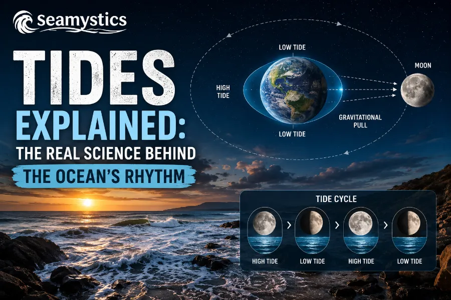
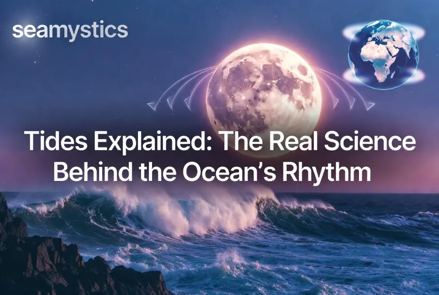
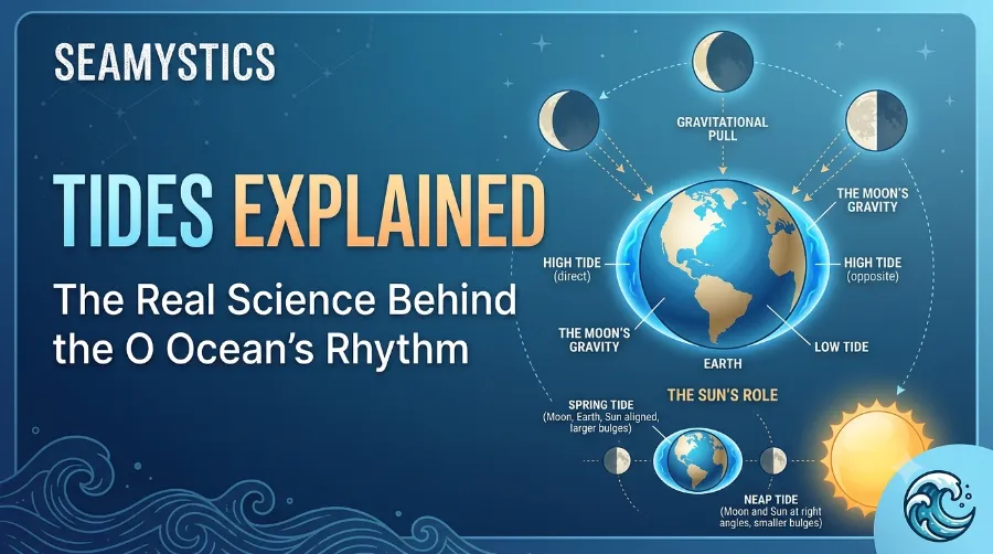
The moon is the main reason tides happen at all. Even though it is small compared to Earth, its gravity is strong enough to tug on the ocean because water moves so easily. As a result, water on the side of Earth facing the moon gets pulled upward, forming a bulge.
At the same time, a second bulge forms on the exact opposite side of the planet. This happens because of inertia, the same force that pushes you sideways in a car during a sharp turn. So while one side of Earth is pulled toward the moon, the far side is essentially left behind, creating a matching bulge there too.
The sun also plays a role, though a smaller one, since it sits much farther away. Together, the sun and moon create a tug of war that decides how strong or weak each day’s tides will be. This is also part of the reason ocean currents behave the way they do, since moving tidal water often blends with wind driven and density driven currents along the coast.
Why Two High Tides a Day?
As Earth spins on its axis, different coastlines rotate through these two bulges roughly every 24 hours. Consequently, most places on Earth experience two high tides and two low tides daily. However, the timing and height depend heavily on local geography, ocean depth, and even the shape of the seafloor.
Types of Tides You Will See Around the World
Not every coastline follows the same pattern. Because land shapes, ocean depth, and the Coriolis effect all interfere with the moon’s pull, tides fall into three main categories.
- Semidiurnal tides: Two high tides and two low tides each day, with roughly equal heights. Most of the U.S. East Coast follows this pattern.
- Diurnal tides: Only one high tide and one low tide per day. This pattern is common in parts of the Gulf of Mexico.
- Mixed semidiurnal tides: Two high and two low tides daily, but with noticeably different heights. This is common along the U.S. West Coast.
Understanding which pattern applies to your local coast can genuinely change how you plan a fishing trip, a boat launch, or even a beach vacation.
Spring Tides vs Neap Tides
Twice a month, during the full moon and new moon, the sun, moon, and Earth line up almost perfectly. When this happens, their combined gravity creates unusually strong tides called spring tides, even though the name has nothing to do with the season. Meanwhile, during the first and last quarter moon phases, the sun and moon pull at right angles to each other, canceling out some of their force and producing smaller neap tides.
| Tide Type | Moon Phase | Tidal Range | Frequency |
|---|---|---|---|
| Spring Tide | Full moon or new moon | Larger than average | Twice a month |
| Neap Tide | First or last quarter moon | Smaller than average | Twice a month |
This cycle repeats every 14 to 15 days without fail, which is part of why tides feel so predictable once you know the pattern. It is also why coastal planners and fishermen still rely on lunar calendars, a tradition that goes back centuries.
Real World Tide Records Worth Knowing
Some coastlines take this natural rhythm to extremes, and nowhere proves this better than Canada’s Bay of Fundy. Located between Nova Scotia and New Brunswick, this bay experiences a tidal range of roughly 16.3 meters, which is taller than a four story building. Around 160 billion tonnes of seawater move in and out of the bay with every single tide cycle, a volume greater than the combined flow of all the world’s rivers.
The extreme range happens because of tidal resonance, a phenomenon where the natural sloshing rhythm of the bay matches the timing of the incoming Atlantic tide almost perfectly. On the night of October 4 to 5, 1869, a storm known as the Saxby Gale combined with a spring tide to push water levels in the bay to an astonishing 21.6 meters, the highest tide ever recorded in that system. Events like this show how tides, weather, and geography can combine into something far more powerful than gravity alone.
If you are curious about how ocean depth interacts with these dramatic water level changes, our guide on the true depth of the ocean breaks it down further.
How Scientists Measure and Predict Tides
Modern tide prediction relies on a mix of history, satellites, and constant monitoring rather than guesswork. NOAA alone tracks tide data at more than 3,000 stations along the U.S. coastline, feeding this information into models used by ships, fishermen, and coastal engineers every single day.
Here is a simplified look at how the process works:
- Sensors at coastal stations record water height every six minutes using acoustic and pressure based tools.
- This data is transmitted by satellite back to NOAA’s monitoring centers for processing.
- Scientists combine current readings with decades of historical tide patterns for that exact location.
- A predictive model then generates tide charts, showing expected high and low tide times months or even years in advance.
- These charts are published publicly so ships, harbors, and coastal residents can plan around them safely.
Because of this system, tide predictions are remarkably accurate, even though local weather can still shift the numbers slightly on any given day.
Why Tides Actually Matter
Tides are not just a curiosity for beachgoers. They shape entire ecosystems, economies, and even how oceans got their basic chemistry in the first place, something we cover in more detail in our piece on the origins of Earth’s oceans.
- Fishermen depend on tidal timing since fish activity often peaks during incoming or outgoing tides.
- Coastal ecosystems like mudflats and estuaries rely on the daily flooding and draining that tides provide.
- Shipping and port operations schedule loading times around tidal windows to avoid running aground.
- Tidal energy projects, including experimental turbines in the Bay of Fundy, are being tested as a renewable power source.
Interestingly, tides also connect to broader ocean mysteries, including why the ocean tastes salty and why so much of the seafloor, roughly 80 percent by some estimates, remains unexplored even today.
Tides and a Changing Climate
Recent research shows that rising sea levels are gradually shifting baseline tide heights in many coastal cities, making so called nuisance flooding more frequent during high tide events. According to NOAA’s coastal monitoring reports, this kind of high tide flooding has become noticeably more common along the U.S. East Coast over the past two decades. As a result, coastal planners are now factoring tidal data into long term flood risk models rather than treating tides as a fixed, unchanging pattern.
For a deeper explanation of the forces behind these coastal shifts, National Geographic’s educational resource on cause and effect in tides offers additional detail worth exploring (https://education.nationalgeographic.org/resource/cause-effect-tides/). Similarly, Vaia’s ecological conservation resource covers how tidal ecosystems respond to these changes over time (https://www.vaia.com/en-us/explanations/environmental-science/ecological-conservation/ocean-tides/).
Frequently Asked Questions
What causes tides in simple terms?
Tides happen because the moon’s gravity pulls ocean water into two bulges, one facing the moon and one on the opposite side of Earth. As Earth rotates, coastlines pass through these bulges, creating high and low tides.
Why are there two high tides a day instead of one?
Because Earth spins through both gravitational bulges roughly every 24 hours, most coastlines experience two high tides and two low tides daily.
Where is the highest tide in the world?
The Bay of Fundy in Canada holds that record, with tidal ranges reaching about 16.3 meters due to a rare resonance effect between the bay’s shape and the Atlantic tide cycle.
Do tides affect the entire planet the same way?
No. Local geography, seafloor depth, and coastline shape all change how strong or weak tides appear in different regions, which is why tide charts differ by location.
Can tides be predicted accurately?
Yes. Agencies like NOAA combine historical data with real time sensor readings to generate highly accurate tide charts months in advance.
Conclusion
Tides may look like a simple rise and fall of water, but they are actually the result of a finely tuned balance between gravity, rotation, and geography. From the gentle daily rhythm along most coastlines to the dramatic 16 meter swings inside the Bay of Fundy, this pattern shapes fishing schedules, coastal ecosystems, and even how cities plan for future flooding. The more you understand this rhythm, the easier it becomes to appreciate just how connected the ocean really is to daily life on land. To keep exploring more surprising ocean facts, visit the Sea Mystics ocean facts hub or head back to our homepage for more marine science explained simply.
References
- NOAA National Ocean Service, “What Are Tides?” https://oceanservice.noaa.gov/facts/tides.html
- NOAA NESDIS, “What Causes Tides?” https://www.nesdis.noaa.gov/about/k-12-education/oceans-coasts/what-causes-tides
- National Geographic Education, “Cause and Effect of Tides” https://education.nationalgeographic.org/resource/cause-effect-tides/
- Vaia, “Ocean Tides: Ecological Conservation” https://www.vaia.com/en-us/explanations/environmental-science/ecological-conservation/ocean-tides/
- NOAA, “JetStream Max: Bay of Fundy” https://www.noaa.gov/ocean/fundy-max